Imagine a city where car horns never blast and traffic lights don’t exist. Venice, Italy, brings this to life—there’s nowhere else quite like it. Built across 118 small islands, all linked by 150 canals and 400 bridges, Venice runs without ordinary roads or motor vehicles.

This floating city has been thriving for over a thousand years, relying on water instead of pavement. Locals and tourists get around by boat, gondola, or hopping on water buses called vaporettos. Without cars, the whole place feels surprisingly peaceful—almost like stepping into another era.
Venice just works differently. Groceries arrive by boat, and even ambulances cruise the canals. You see neighbors chatting on bridges, and everything moves at a slower, more human pace.
Key Takeaways
- Venice is a car-free city, spread over islands where canals act as streets and boats are the main way to get around
- Daily life means creative problem-solving—think hand-carrying groceries and trekking over countless bridges
- No motor vehicles means the city stays unusually quiet, keeping old traditions and a sense of community alive
Why Venice Is Known as the City Without Roads

Venice got its nickname because it sits on 118 islands, all joined by canals and bridges—no roads in sight. The geography and old-school engineering left boats as the only real option for getting around or hauling goods.
Origins of a Water-Based City
Back in the 5th and 6th centuries, people settled here to escape invaders on the mainland. They picked these marshy lagoon islands for safety.
The muddy ground and constant flooding meant regular roads just weren’t possible. There was no way to lay solid foundations.
Early Venetians switched to boats for everything—travel, trade, even chatting with the neighbors across the water. Small wooden boats became part of daily life.
This watery way of life shaped how Venice grew. Buildings went up on wooden pilings hammered deep into the lagoon. Instead of streets, canals took over, and boats replaced horses and carts.
With no solid ground to work with, Venetians had to get creative. They built a city around water, not land.
Venetian Lagoon and Island Formation
The Venetian Lagoon covers about 212 square miles of shallow water, wedged between the mainland and the Adriatic Sea.
118 islands make up Venice’s historic heart, each one separated by natural channels or hand-dug canals.
The lagoon’s quirks include:
- Shallow water—usually 3–6 feet deep
- Tides that flush the canals twice a day
- Natural barriers that help block ocean storms
- Mudflats and marshes that keep the ground soft and unstable
Over thousands of years, tides and sediment built up these little islands. Each patch of land stayed isolated unless someone built a bridge or used a boat to cross the water.
Historic Engineering and Urban Design
Venetian builders came up with wild solutions to make a city float. They pounded millions of wooden stakes into the lagoon to hold up buildings.
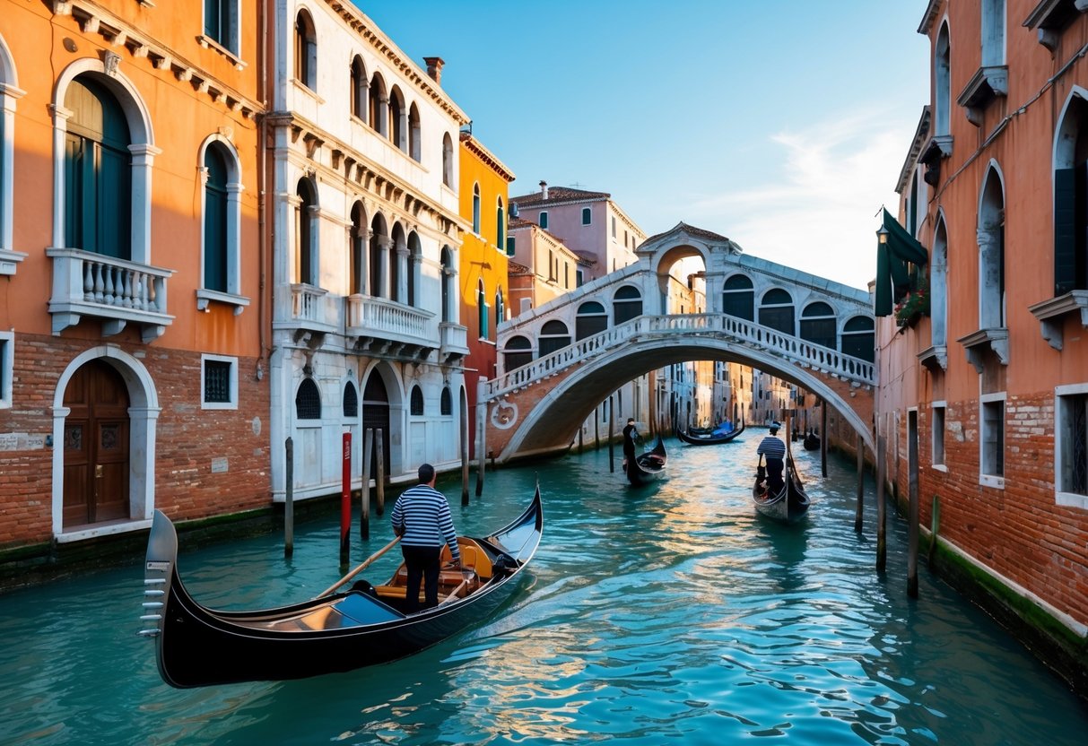
The canals are Venice’s streets. The Grand Canal is the main drag, with smaller canals zigzagging through neighborhoods.
There are over 400 bridges connecting everything, but they’re built for feet, not wheels. Most are stone or iron, spaced out so you’re never far from a crossing.
Venice’s design includes:
- Water taxis for quick trips
- Gondolas for the classic experience (mainly for visitors now)
- Cargo boats that deliver everything from food to furniture
- Pedestrian paths running along the canals
Buildings face the water, not courtyards, so boats can pull right up to the front door. There’s just no room for cars, and the bridges only work for walkers.
Life, Transportation, and Daily Challenges in Venice
Venetians get around by boat or on foot—cars just aren’t part of life here. Every day means walking over bridges and dealing with floods that can slow everything down.
Navigating the Canals: Boats and Gondolas
The Grand Canal is the city’s main thoroughfare. Vaporetti (water buses) shuttle people between the 118 islands on set routes. They’re the city’s public transit, running all day.
Private water taxis are quicker but pricey. Many locals have their own small motorboats, which they tie up at docks or marinas close to home.
Gondolas are mostly for tourists these days. Locals rarely use them—they’re slow and expensive. Gondoliers actually need a special license and a lot of training to steer through the busy canals.
Delivery boats bring supplies to shops and restaurants early each morning, squeezing through the tight waterways to drop off goods. They have to stick to strict schedules to keep the canals from getting jammed.
Canal traffic has rules. Boats keep to the right. There are speed limits to stop waves from damaging buildings. Water police keep an eye on things and hand out tickets if needed.
Walking the City: Bridges and Pedestrian Routes
With over 400 bridges, Venice is a city for walkers. Most bridges have steps, so rolling carts or bikes are a pain. People end up lugging groceries up and down stairs all the time.
Everyone walks everywhere in the historic core. It’s only about three square miles, so you can reach most places on foot. Narrow stone alleys snake between buildings and over canals.
Yellow street signs point the way to big landmarks like Rialto and San Marco. They help a bit, but plenty of streets end at water with no bridge in sight.
Campos—open squares—are where paths meet and people hang out, shop, or grab a coffee. Most neighborhoods have their own little campo surrounded by shops and bars.
Tourists get lost a lot here. GPS signals don’t always work because of the tall buildings, so old-school paper maps are still handy.
Managing Acqua Alta and Seasonal Flooding
Acqua alta (high water) floods Venice’s streets and squares during certain tides, mostly from October to March. Water can rise a few feet above normal, making it tricky to get around.
Locals check tide forecasts and listen for sirens or phone alerts. Tall rubber boots are a must, and people plan different routes when the water’s high.
During floods, the city sets up wooden walkways—passerelle—so folks can cross the worst spots without getting soaked. Shop owners move stuff upstairs when flooding threatens.
The MOSE flood barriers now help keep out the worst of it. These giant gates close when dangerous tides roll in, and they’ve cut down on severe flooding since they started working.
Some shops close if the water gets too high. Getting around is tough when steps and walkways are underwater. People stock up on food and supplies before a big flood so they don’t have to wade through it.
Frequently Asked Questions
Venice’s car-free setup makes people curious about daily life here. Locals rely on boats and walking, while emergency crews use special water vehicles to get around the canals.
How do residents navigate around Venice?
Venetians stick to two main ways: walking and boats. Walkways and bridges link all 118 islands.
People stroll along narrow “calli” (streets) and cross bridges all day. The network of paths reaches most places you’d want to go.
For longer trips, water taxis or vaporetti (public water buses) are the go-to. If you can afford it, a private boat is handy.
Locals know shortcuts through tiny alleys and hidden passages. That insider knowledge makes it easier to zip through the maze.
What is the main mode of transportation in Venice?
Boats are king in Venice. They take the place of cars, trucks, and buses.
Vaporetti run like city buses, but on water. They follow set routes and connect different parts of town.
Water taxis are faster but cost more. They’ll take you right where you need to go.
Gondolas? Mostly for the tourists. Ages ago, wealthy locals used them for everyday travel, but not anymore.
Walking is still crucial. A lot of errands mean a mix of walking and boating.
What measures are in place to maintain the structural integrity of Venice’s buildings?
Venetians use special building tricks to keep things standing on water. Buildings rest on wooden piles driven deep into the lagoon.
The city checks foundations all the time. Engineers look for settling, leaks, or weak spots.
Stone and brick help resist water damage. Istrian stone is a favorite—it stands up well to saltwater.
Regular upkeep means waterproofing and fixing foundations. Major repairs need city permits to make sure people do them right.
The MOSE barriers also help, blocking high tides and preventing floods from damaging buildings.
How does the absence of roads impact emergency services in Venice?
Emergency crews use boats instead of regular vehicles. Ambulances, fire trucks, and police cars all have water-based versions.
Firefighters use fireboats with pumps that pull water straight from the canals.
Ambulance boats carry patients and medical gear to hospitals.
Police patrol in fast boats, able to handle water emergencies or reach land spots via canal access.
Response times can be a bit longer than in cities with roads. Crews have to deal with canal traffic and the weather, too.
What is the historical significance of Venice’s canal system?
Venice’s canals go back to the 5th century. Early settlers dug channels between the natural islands.
The canal network made Venice a trading powerhouse. Ships could sail right into the city to load and unload.
The Grand Canal was the main route for business, with grand palaces lining the banks as a show of wealth.
Canals also protected Venice from attacks—invading armies couldn’t just march in.
This unique design shaped Venice’s art, buildings, and way of life, making it famous the world over.
What are the challenges of conserving Venice’s architecture and waterways?
Rising sea levels put Venice’s buildings and foundations at risk. Climate change just keeps making the flooding and structural damage worse.
Saltwater eats away at building materials every day. Stone, brick, and metal all end up suffering from erosion and decay—it’s relentless.
Tourism draws millions of people each year. All those feet, plus the constant wakes from boats, really wear down the buildings and canal banks.
Keeping everything in shape costs a fortune. Restoration in this watery setting demands specialized workers and materials, and that’s never cheap.
Pollution from boats and local industry damages the lagoon’s ecosystem. Trying to clean up the water? Well, that often clashes with the city’s transportation needs and economic pressures.
Comments